This webpage contains information about the significant ongoing remediation process following the Tylorstown landslip.
LATEST NEWS: Important progress with drainage works at Tylorstown Landslip site (September 2026)
The Council has provided a progress update on the ongoing activity at the Tylorstown Landslip site, which continues to focus on the extended works in Phase Four of the Remediation Plan – with this work nearing completion: Read more
On February 16, 2020, the landslip occurred on the Llanwonno hillside at Tylorstown, as Rhondda Cynon Taf was hit by three storms in quick succession. The landslip was triggered by Storm Dennis – a one in 200-year storm event that saw Maerdy at the top of the Rhondda Fach record the highest volume of rainfall in Wales. The site is a Category D tip and was being inspected every three months against a set of monitoring criteria prior to the storm, and inspections have subsequently increased in frequency since.
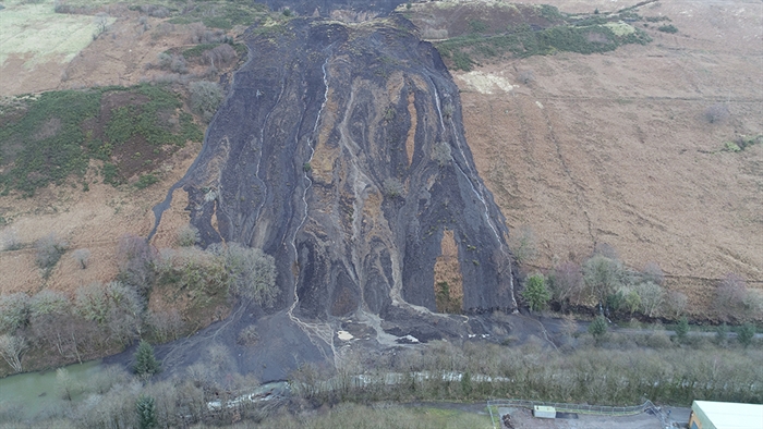
How the landslide initially appeared after it occurred in February 2020 (above) and the landslip area following Phase Three in autumn 2021 (below)
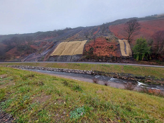 The landslip blocked the river valley, broke a foul sewer, covered a strategic water main with several metres of debris, and covered a footpath and cycle path. The area was closed to members of the public to ensure safety with immediate effect.
The Council is working towards a four-phase remediation plan, as outlined below:
- Phase One – Emergency drainage and vegetation clearance (completed in the weeks following the landslip).
- Phase Two – Embankment scour repairs (commenced in late June 2020, and was completed in June 2021).
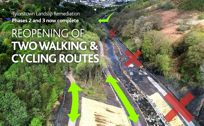
- Phase Three – Moving of material to receptor sites and temporary reinstatement of paths (commenced in late June 2020, and was completed in June 2021). An additional phase of work to stabilise the slope above the one remaining closed footpath was completed in autumn 2021.
- Phase Four – Remediation of the remaining tip on the hillside. Planning permission was granted in October 2022 and works started on site in April 2023. It will enable future enhancements to the community route. The original drainage programme and scope of the work have been significantly extended and are currently ongoing during 2026/27.
- Cycle routes and receptor sites – Improvement works to several structures along the proposed Community Route in the future. The route will be resurfaced and works to the receptor sites completed.
Phases Two and Three
On June 10, 2020, the Council made an announcement outlining its intention to commence the second and third phases of work – starting by the end of June and ending later this year in accordance with Natural Resources Wales’ restrictions about working in the river from the end of October onwards. The announcement also confirmed that the Council is working closely with the Welsh and UK Governments over the funding options to cover the costs of Phases Two and Three, which are estimated to be around £2.5m. Here is the Council Leader at the time, Councillor Andrew Morgan OBE, speaking before the start of Phases Two and Three in June 2020:
The Council made an Urgent Delegated decision on June 11, 2020, to progress the work, and to appoint a contractor.
Works to deliver Phases Two and Three got underway on Monday, June 29, 2020 - after the Council appointed Walters as the contractor responsible for carrying out the scheme. Walters, which also undertook Phase One, is an experienced local contractor which has been involved in tips schemes such as this one in the past.
Phases Two and Three were completed on June 25, 2021. This followed a number of landmarks being achieved on site – such as removal of the slipped material from the valley floor, the reinstatement of the river to its correct line and level and a series of drainage works.
Ecological impact
In terms of the ecological impact, a number of surveys have been carried out by consultant ecologists in liaison with the Council’s ecologist and Natural Resources Wales (in relation to the clearance of undergrowth and trees from the receptor sites – together with the impact on flora and fauna).
All parties continue to work together to ensure the impact on the environment is minimised where possible. Consideration is being given to the final receptor sites and how this will benefit the ecology of the river valley.
Receptor sites
The three receptor sites are owned by Rhondda Cynon Taf Council, and are located to the north of the landslip site, alongside the former railway line. Receptor Site B (nearest the landslip site) formed part of the old railway sidings, and receptor Site A1 and A2 was a former colliery site footprint.
Planning permission for the receptor sites (temporary) for the slip material was subsequently applied for retrospectively, and it was granted by the Planning and Development Committee on Thursday, January 21, 2021. The agenda for that meeting can be found here.
During spring 2024, all work was completed at Receptor Site A2. Council officers are progressing towards the final implementation of the works at Receptor Site B.
Placing the spoil material on these sites has significantly reduced the amount of material which would have otherwise be moved along the public highway. The receptor sites have also ensured that the wider works are self-contained – and therefore the carbon footprint of the works is greatly reduced. For instance, there have been virtually no vehicles on the public highway from the site, which would otherwise cause noise, vibrations, air pollution, dust and damage to the carriageway. It is estimated that the process of moving 60,000 tonnes of material would have required 6,000 lorry movements – which was avoided by utilising the receptor sites.
Phase Four
The Council undertook a Pre Application Consultation with the community in January and February 2022, so residents could have their say on Phase Four – with the feedback received helping Officers to finalise the planning application. Officers organised a public exhibition at Rhondda Fach Sports Centre (May 19, 2022) for residents to attend for a further progress update.
Full planning permission was granted for Phase Four, by the Planning and Development Committee, in October 2022.
The planning application that was granted for Phase Four (ref. 2022/0600/08) covers a number of works, including relocating colliery material to a site adjacent to the tip, and reprofiling/stabilising the upper tip site. It also includes new drainage work, the formation of access tracks and paths, vegetation regeneration and ancillary works. Find more information on the Council’s planning portal here. Hard copies of documents can also be viewed at Porth, Ferndale and Pontypridd Libraries.
The appointed contractor Prichard’s Contracting, which is based in Llantrisant, started the main works for Phase Four during April 2023.
This drone footage from June 2024 shows the progress being made in Phase Four.
The Council also made two further planning submissions in December 2022, relating to proposed works at receptor sites within Phases Two/Three of the remediation plan. These include a proposed planting scheme of trees for Receptor Site A2 (ref. 22/1477/08) and proposed bench seating, small footbridges over drainage channels tying into the local path network, interpretation panels and a ‘stepping stone feature’ for Receptor Site B (ref. 22/1476/08). The links included above give more information on the Council’s planning portal.
Significant extension of works in Phase Four
The major drainage programme within Phase Four has been substantially extended as a necessary measure, due to the discovery of water ingress and changes with the underlying topography.
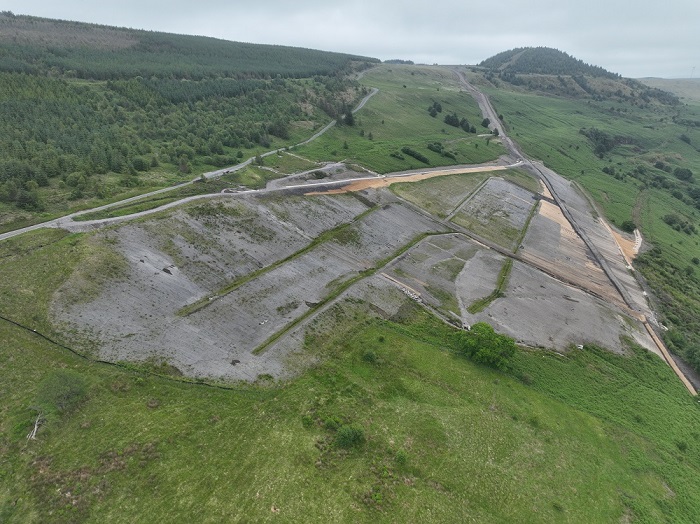
A progress update in June 2025 gave an update on the drainage infrastructure works, and noted that the Upper Llanwonno Tip has been significantly reduced in volume and reprofiled. The update also noted that a longer-term plan for land and habitat management is being put in place, along with a system of technical monitoring which will be installed. By this point, one of the receptor sites used in earlier phases of work (near Station Road in Ferndale) had also been converted into a permanent BMX pump track leisure facility. The below image is from June 2025.
A further progress update in late September 2026 reported on the significant progress that had been made with the drainage infrastructure works.
The main spine drains that collect water from the reprofiled tip were completed, while important attenuation work (to slow down the water flows before they are discharged to existing streams) was being progressed on site. The receptor site to the rear of the tip (near Old Smokey), where a large amount of the colliery spoil from the upper tip was transported, was successfully regenerated.
The update also noted that the contractor is using specialist plant equipment (pictured below) to repair and maintain the channel outfall below a new cascade.
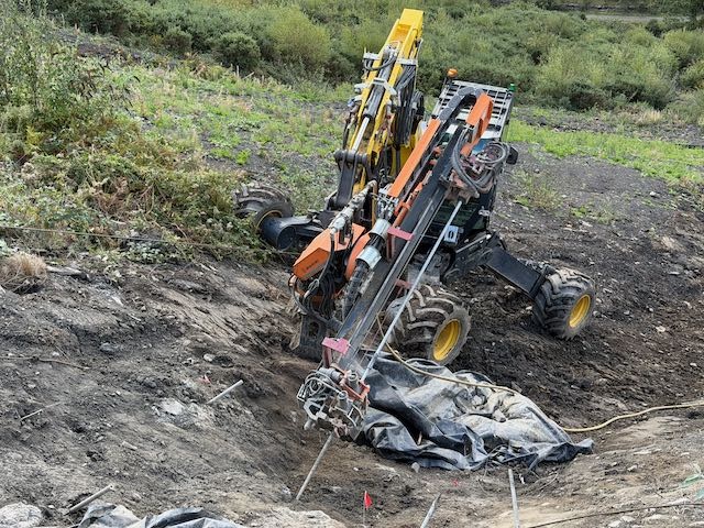
This is to future-proof the water run-off past the southern edge of the lower tip. Soil nailing works at the bottom of outfall A is pictured below. This represents the last major work at the bottom of the site, before the contractor works its way out and up the hill, towards establishing a maintenance track and creating a walking route across the hillside which will connect to existing walking routes which in turn connect to the Rhondda Fach Active Travel Route, a 10km shared walking and cycling route between Maerdy and Tylorstown.
This was completed in four phases of work from 2023 to 2026 – concluding with the final section (Rhondda Fach Leisure Centre to Stanleytown Overbridge) which opened in summer 2026. Please find a dedicated webpage for the Rhondda Fach Active Travel Route, including a map and a video showing the entire path being cycled.
Welsh Government's wider work relating to Coal Tips
Rhondda Cynon Taf Council has welcomed the work the Welsh Government has undertaken since the landslide at Tylorstown. This work has included asking the Law Commission to evaluate current legislation for managing coal tips safety in Wales – with a public consultation running from June to September in 2021. Details here.
Following on from this, Welsh Government launched a separate consultation on its Coal Tip Safety White Paper from May 12, 2022. Details here.
Monitoring equipment installed on the National Tip in Wattstown
From November 2023, Welsh Government has included a function on its website where residents can search the location and boundaries of all disused Category C and D coal tips in Wales. Find out more and access this resource on the following link.